See photos (3)
Historic Path of Le Palais
Cultural, Historic, Discovery lanes on foot
in Le Palais
Walking/pedestrian
1h 30min
Easy
-
Along the streets of Palais, along the course of history.
-
The town of Palais is fortunate to possess numerous vestiges of its rich past within its boundaries. Prestigious or modest, they dot our streets and are part of our everyday landscape. Seventeen panels recount the history of some of our town's key locations. Visitors can explore Palais from the Montagne district to the outer harbor, passing by the Place de la République, the church, and the town hall, and discover the history of these places.
- Departure
- Le Palais
- See all reviews
- Points of interest
1
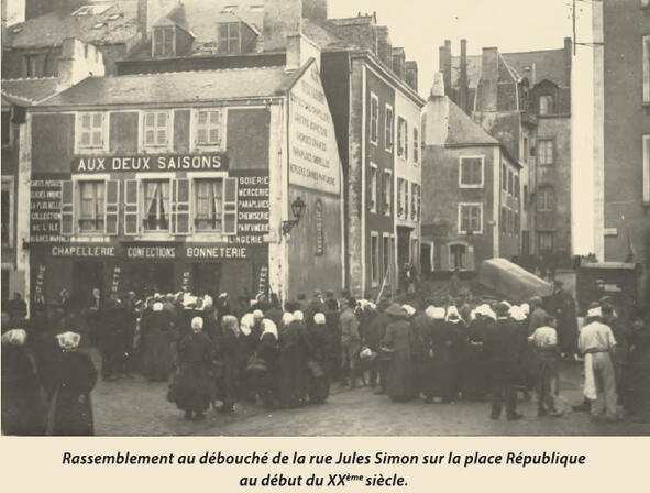
Jules Simon Street
Shaped by fishing, wars and military occupations, “Paloë” — meaning “the town of the great island” — became Le Palais, a lively town that has embraced modern life without forgetting its history or heritage.
From the harbour to the old town walls, from forgotten chapels to Saint Louis Hospital, from the church to the washhouse, from La Saline to the citadel, Le Palais reveals itself little by little through its streets and its history.
Jules Simon Street, named in honour of the philosopher and statesman Jules Simon (1814–1896), was once known as Sables Street, after the neighbourhood it served.
Narrow and winding, it was once too tight even for carts, while maritime activity was concentrated in the outer harbour. For many years, local residents opposed widening the street, fearing that the sea, driven by easterly winds, might rush in and flood the surrounding neighbourhoods.
In 1896, the decision was finally made to widen it. The work took seven years and led to the demolition of two buildings. Escaliers Street, which had to be realigned, lost a few of its steps in the process. Because of its position facing the sea, locals still call it the “draughty street” today.
Escaliers Street, whose steps are cut directly into the rock, took its current name in 1842. It was formerly known as Breakneck Street and leads to the Montagne de Port Hallan district, which rises above the town to the east. This area became home to the town hall in 1852, followed by two schools, several canneries and, in 1894, a maritime school.
This was also the district where General Bigarré was born in 1775. He owned a large house at the corner of what is now Bihan Street, where he created themed gardens and planted hundreds of fruit trees.
Ramparts Street, long known as Military Street, overlooks the outer harbour. Its strategic location made it possible to control access to the town from the sea.
2
The town walls
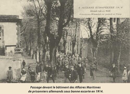
On the right, we pass an old fish cannery. In 1881, Belle-Île had thirteen canneries. This one, opened in 1850, processed sardines and tuna, but also vegetables when fish were scarce. It closed in 1893 and was later requisitioned in 1915 to house 400 German prisoners of war.
At the corner of Rue des Remparts and Rue Dixmude, more canneries were established from 1860 onward. In 1894, one of them became the Port Hallan Maritime School, created to train underprivileged or orphaned young men for seafaring professions. In 1913, it returned to its original use as a cannery.
On the left, the casemates are reminders of the German occupation of Belle-Île from June 1940 to May 10, 1945.
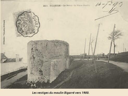
Nearby are the remains of the old Bigarré mill, the last of four mills in Le Palais. It stopped operating in 1844 when it was purchased by the army—its moving sails interfered with coastal defense.
The curtain wall continues toward Redoubt A, passing the Porte de Locmaria, built between 1849 and 1850. Like the Porte Vauban, it connects the town with the countryside and the roads leading to Port Hallan and Ramonette.
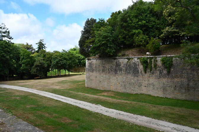
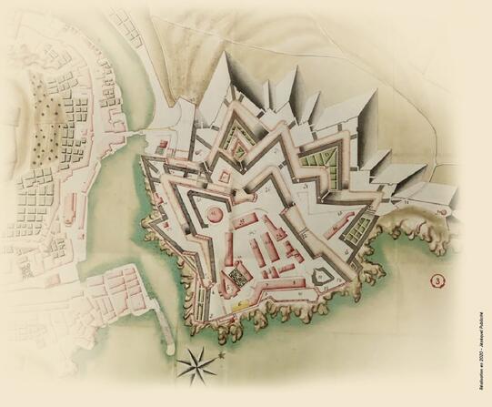
3
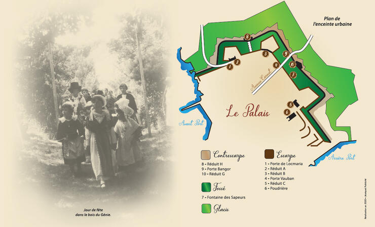
Urban fortification
The fortification starts at the seafront, above the outer harbour, and ends at La Saline. On the other bank, it is completed by the Beausoleil work.
It consists of:
An escarpment, starting at the sea and including several structures: the Porte de Locmaria (1), Redoubt A (2), Redoubt B (3), the Porte Vauban (4), Redoubt C (5), the powder magazine (6), as well as bastions and curtain walls.
A ditch, beginning at the Ramonette road and extending to the hospital, with the Sapeurs fountain (7).
A counterscarp, beginning at the Ramonette road and ending at La Saline, with Redoubt H (8), the Bangor Gate (9), Redoubt G (10), and casemates running along the whole length, as well as, behind the Porte Vauban, the medical shelter built during the Second World War.
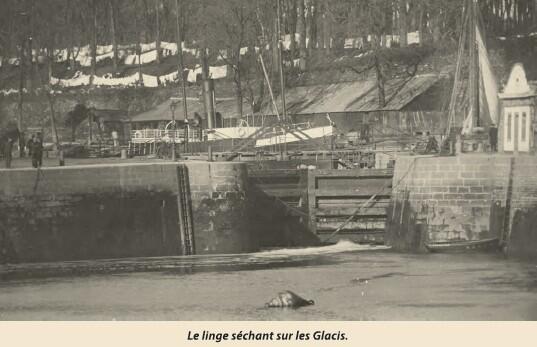
Beyond the counterscarp, a glacis slopes down towards the countryside.
Listed as a Historic Monument in 2004, the urban fortification is a rare and remarkable example of 19th-century defensive military architecture.
4
Saint Sebastian Chapel
Damaged during the English occupation in 1761, the chapel was restored three years later.
In 1778, it served as a chapel annex to the church of Le Palais for Breton-language services, while French-language services were held in the parish church.
1791 — The chapel became the meeting place of the Club of the Defenders of Liberty, before being assigned to the army, which converted it into a hospital for people with scabies.
1793 — The cemetery was closed and moved to its current location on the Sauzon road.
1795 — The departmental forage inspector obtained permission from the municipality of Le Palais for the chapel to be used as a storage place for the garrison’s fodder.
1818 — The Ministry of War lent part of the building for the creation of a mutual teaching school.
1838 — The chapel was partly demolished to become the home of the Engineer Commander.
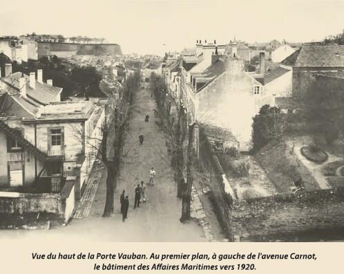
After the army left, the building was handed over by the War Administration to the Maritime Affairs Department, which occupied it until 1995.
I can also turn this into a more elegant brochure-style version if you want it to sound more fluid for visitors.
5
Jules Ferry Avenue, Verdun Street
It is a long building, hastily constructed in 1812 with schist walls and a thatched roof. Quickly improved, it was eventually able to house up to 600 men. It was used temporarily as a municipal boys' school in 1852, before becoming an annex to the hospital in 1914 to house wounded German prisoners. When the army finally left Belle-Île in 1920, the barracks were decommissioned and sold to local cannery manufacturers, later serving as a holiday center. From 1855 to 1883, the building at number 2, Avenue Jules-Ferry, also served as the living quarters for the five men of the island’s first gendarmerie brigade.
Rue de Verdun and the Chapel of the Ladies
Rue de Verdun winds gently down toward the Town Hall square. On the right, at number 1, you will find an old chapel built in 1723 by the Congregation of Women, known as the "Chapelle des Dames" (Chapel of the Ladies). It was destroyed when British troops captured the island in 1761, but it was later restored and converted into a military storehouse in 1775.
In 1799, it became a "Decadal Temple," where Republican weddings were celebrated and where the local citizens would gather every ten days to hear the reading of new laws. In 1832, it served as a hospice during the cholera epidemic. In 1949, the parish purchased the chapel and converted it into a youth center, which today serves as the headquarters for the Guerveur brass band.
As you explore, keep an eye on the houses at numbers 12, 19, and 22. In particular, note number 2, which features a charming projecting staircase turret and a curious Greek bas-relief, brought back from his travels by the naval officer Jacques Le Blanc.
6
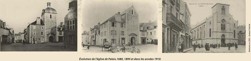
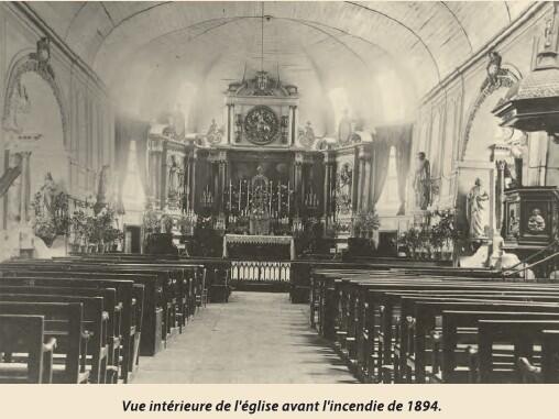
The Church of Le Palais
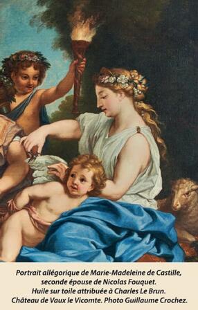
The original church of Le Palais was located in the Haute Boulogne district, the heart of the old town. By 1674, as the population began shifting toward the lower town (Basse Boulogne), it was decided that a new church should be built on the current site, on land donated by Madame Fouquet. Construction began in 1677 and was completed in 1680.
At that time, shops and houses were built against the church walls, providing a significant source of income for the parish. Many of the interior’s original decorative elements were preserved and can now be viewed at the Citadel Museum. During the French Revolution, in 1791, these adjoining properties were confiscated and sold at auction, while the church itself was stripped of its bells and ornaments, briefly becoming a "Temple of Reason" in 1794.
From Fire to Art Deco Splendour
In 1875, the church was enhanced by a magnificent organ, originally crafted 12 years earlier by the renowned organ builder Cavaillé-Coll for the Théâtre de la Gaîté Lyrique in Paris. Its exceptional quality led to it being designated a protected historical object in 1988. Following a partial fire in the bell tower in 1894 and given the building's general state of decay, a decision was made in 1905 to construct the current church, which was blessed on November 23, 1906.
The church's striking Art Deco interior was commissioned in 1922 by Father Rio. The intricate work was carried out by the Mauméjean studios over a decade, from 1931 to 1943. This artistic ensemble includes 18 stained-glass windows depicting the life of Christ, a grand rose window above the altar representing the Holy Trinity, and a breathtaking collection of mosaics covering the chancel, communion table, pulpit, and baptismal font.
Above the altar stands the statue of Christ the King—to whom the church is dedicated—surrounded by saints once honoured in the various chapels of Belle-Île, including Saint Géran, the patron saint of the Le Palais parish.
A Modern Landmark
In 1992, the building was finally completed with a bell tower housing four bells: Marie-Jeanne, Emmanuelle, Anne-Marie, and Gérane. In recognition of its cultural significance, the church was officially listed in the Supplementary Inventory of Historic Monuments on July 31, 2015.
7
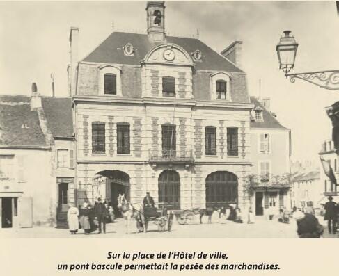
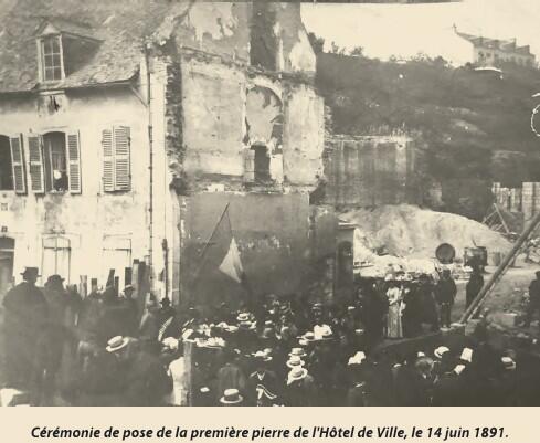
The Town Hall
The first municipal government of Le Palais was elected in 1789. Initially lacking a dedicated building, officials met in the home of Mayor Le Grand, located on what is now the Place de la République. Throughout the 19th century, the town hall occupied various houses across the town, either purchased or leased specifically for that purpose.
In 1893, designed by architect Gallot, the current Town Hall was constructed in the heart of Le Palais, facing the church on the site of the former Aubert estate, a wealthy local merchant family. Following the vision of Mayor Poupart to create a true administrative hub, the building was designed to house not only the mayor's offices but also the post office, the justice of the peace, a covered market, and the gendarmerie.
Architectural Charm and Heritage
Built in the Louis XIII style, the Town Hall is characterized by its alternating cut stone and red brick quoining, high chimneys, and a charming bell turret. Its facade was heavily inspired by the municipal buildings that were flourishing on the French mainland during that era. To ensure the church bells did not have a monopoly on telling time, a clock was installed on the pediment of the "Maison Commune."
Today, with the justice of the peace abolished and the post office and gendarmerie moved to other locations, the Town Hall offices now occupy the entire building. On the first floor, five tall windows overlook the square and illuminate the Council and Wedding Room. This room has retained its original decor, including its elegant woodwork and chandeliers. The walls are adorned with portraits of Admiral Willaumez and General Charles de La Touche, a local historian who served as mayor during the Restoration period.
Opposite the Town Hall, adjacent to the portico, once stood the old market halls and the festival hall, which has since been transformed into the island’s cinema.
8
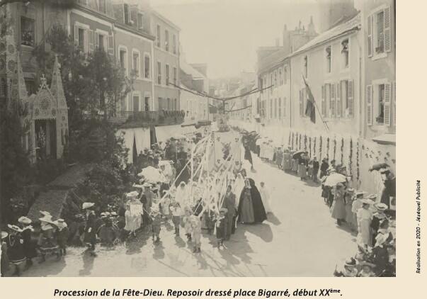
Place Bigarré
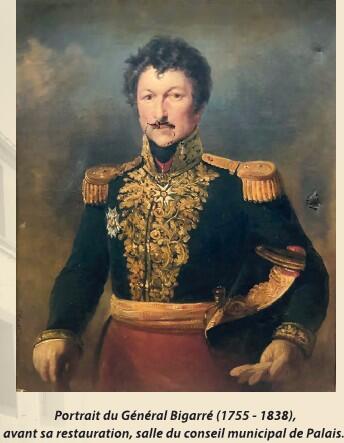
A bustling crossroads since the 17th century, this square was a key meeting point for traffic flowing from the town center, the port, and the hospital bridge. Lined with numerous shops, it once served as the regular site for the local fish market. In 1843, the square was named in honour of Auguste-Julien Bigarré, a Napoleonic general born here in Le Palais on January 1, 1775.
General Bigarré’s life was nothing short of remarkable. Not particularly fond of his studies, he set sail as a cabin boy at just 12 years old before enlisting in the army in 1793. Courageous and enterprising, he quickly rose through the ranks during the Revolutionary, Consulate, and Empire campaigns. By the age of 21, he was a captain, and with the support of Joséphine de Beauharnais, he joined the Consular Guard. After the Battle of Austerlitz, he was awarded the Legion of Honour and became an aide-de-camp to Joseph Bonaparte, King of Naples, who promoted him to Brigadier General in 1808 at the age of 33. Napoleon later made him a Baron in 1810 and a Count in 1814.
After serving as a member of parliament for Ille-et-Vilaine, he was retired following the Battle of Waterloo. He spent his retirement on Belle-Île until 1830, when King Louis-Philippe appointed him commander of the 13th Military Region and raised him to Grand Officer of the Legion of Honour. He passed away in 1838 at the age of 63.
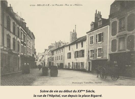
Rue Joseph Le Brix: A Window into the Past
Leading off from Place Bigarré is the oldest street in Le Palais. Since 1932, it has been named after Joseph Le Brix, a famous aviator from the Morbihan region. Originally called "Rue Paluden"—a nod to the marshy grounds that once dominated the area—it was renamed "Rue de l'Hôpital" in 1842. Since the 17th century, this has been a vibrant commercial street, filled with small workshops and boutiques. By the 19th century, it evolved into a lively hub of inns and cabarets frequented by garrison soldiers and sailors.
The street has largely retained its historic character and architecture. Be sure to look for number 28, the most iconic building on the street, easily recognized by its distinctive, high street-facing gable.
9
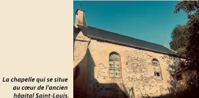
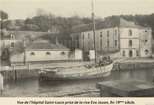
The Saint Louis Hospital
Founded in 1659, the Saint Louis Hospital was the vision of Marie-Madeleine Fouquet, the Marquise of Belle-Île. At her request, Saint Vincent de Paul sent the "Daughters of Charity" to provide medical care to the sick, with the first two sisters arriving in 1660. Following the fall of the Fouquet family from royal favor, King Louis XIV transformed the facility into the "Royal Saint Louis Hospital." Although he dismissed all those who had served the Fouquets, he notably chose to keep the sisters in their roles. The hospital soon expanded its staff to include a chief surgeon and a chaplain.
Centuries of Service
In 1666, the foundation stone was laid for the chapel dedicated to Notre Dame de Miséricorde (Our Lady of Mercy). To this day, the chapel serves as the final resting place for several sisters and prominent military figures from the island’s history. Thanks to a perpetual endowment granted by Madame Fouquet in 1695, the sisters were able to continue their work caring for the destitute and running a school for local girls within the hospital walls.
The hospital grounds expanded significantly starting in 1746, with the addition of two new wings. Shortly thereafter, the main building—housing the infirmary wards—was constructed, later being heightened in 1843.
From Garrison to Modern Medicine
Following the departure of the military garrison at the end of World War I, the hospital transitioned into a civilian establishment. The last of the sisters served as nurses here until 1992. In 1950, a maternity ward was built at the corner of Rue Joseph Le Brix and La Saline; however, it closed in July 1970 following the opening of a new hospital in the La Vigne district. The Yves Lanco Hospital served the community until it was succeeded by the modern "Belle-Île-en-Mer Hospital Center" in 2019.
10
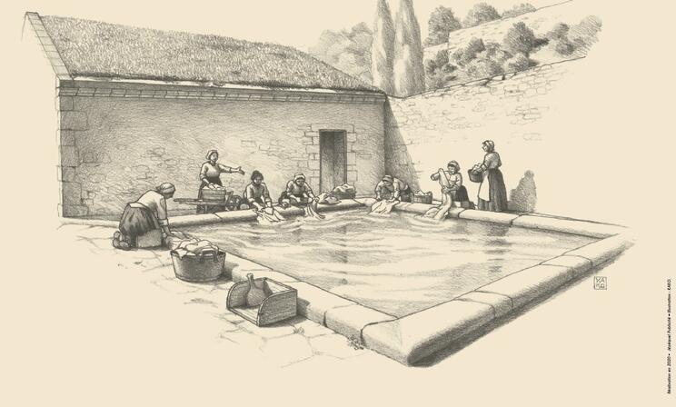
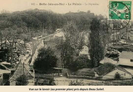
The Garrison Washhouse
Built in 1751 by military engineers, this washhouse was originally dedicated to laundering linens for the garrison. It was quickly adopted by the local population as well, which unfortunately led to frequent disputes between the soldiers and the villagers. The local municipality often petitioned to have the washhouse covered to protect the women from the elements, but the military authorities consistently refused.
It was finally ceded to the City in 1875, on the condition that a water diversion be maintained to supply the military hospital. It remained in active use by the residents of Le Palais until 1975.
The Normande Basin: A Vital Water Source
A short walk away, at the end of the Saline district, lies a small valley known as the "Pré aux Moines" (Monks' Meadow). Two natural springs flow from here, passing through the Potager du Roy (King’s Kitchen Garden) before being channeled into the Bassin de la Normande. Adjacent to the washhouse it feeds, this vaulted, subterranean building can hold up to 60 cubic meters of water.
Constructed in 1750, it was equipped with two water taps: one at 62 cm above the ground for filling the garrison’s barrels, and another at 70 cm for the local inhabitants—a design that gave the Army priority access whenever water levels began to drop. Its architecture was directly inspired by the design of the famous Belle Fontaine on the island. The entire site was beautifully restored in 2015, following the guidance of the Bâtiments de France heritage conservation experts.
11
The Citadel
Coveted for its natural wealth and strategic location, Belle-Île-en-Mer was forced to defend itself against frequent English and Spanish pirate raids from a very early age. During the Middle Ages, monks from Quimperlé built a small fort overlooking the harbour. This structure was later expanded by the Dukes of Gondi and finally transformed into a true citadel by the superintendent Nicolas Fouquet.
When Vauban visited the island in 1683 at the request of King Louis XIV, he declared the fortress to be "one of the best citadels in the kingdom." He skilfully completed the defensive works, creating a 10-hectare star-shaped fortification. To ensure its effectiveness, he famously ordered the demolition of the town located in Basse-Boulogne to establish a clear defensive slope, or "glacis."
Engineering and History
The Citadel was designed to house 800 soldiers and included an arsenal, cisterns, powder magazines, underground tunnels, and five levels of defensive fire. Vauban’s grand plan also relied on a massive urban defensive wall, though he never had the funding required to complete it. This lack of protection proved fatal: during the Seven Years’ War, the English captured the Citadel and occupied the island. Belle-Île was finally returned to France by the Treaty of Paris in 1763, in exchange for Menorca.
From the 17th to the 20th century, the Citadel served as a high-security prison. Its cells held a variety of notable inmates, including the twelve accomplices of "La Voisin" (the infamous poisoner), companions of the revolutionary Georges Cadoudal, the son of Toussaint Louverture, and captives from both World Wars.
A Restored Landmark
Left to decay after the First World War, the Citadel was sold at auction in 1960 to private owners, Anna and André Larquetoux. They took on the monumental task of restoring the site to its original splendour. Today, this privately owned landmark—classified as a Historic Monument since June 22, 2007—is open to the public, offering a fascinating glimpse into the island's military past.
12
The Citadel Bridge
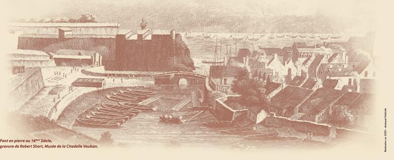
There has always been a crossing point connecting the Citadel and the old town of Haute Boulogne to the harbour. In the 16th century, a cut-stone bridge was built to span the narrow entrance to the inner harbour, and in 1685, the military engineer Vauban suggested that adding a lock would be a wise improvement.
After sustaining damage, the bridge was rebuilt in 1714. However, its arch was so low that boats could not pass underneath at high tide. Despite this, it remained a vital route for local residents and carts traveling between the town, the Citadel, and the springs on the other side of the harbour. During this period, this part of the port was primarily used to shelter fishing boats during the winter.
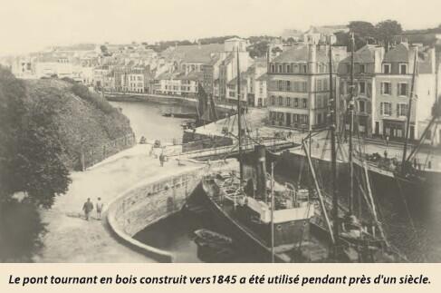
From Swing Bridge to Modern Gateway
By 1830, the bridge was in danger of collapsing and was demolished, replaced temporarily by a footbridge. Fifteen years later, a wooden swing bridge and a new lock were installed. This turned the inner harbour into a "wet dock," capable of accommodating the large coastal vessels essential for supplying the island, while also providing a space for shipwrights to perform hull maintenance. In 1844, the lock-keeper’s house was built at the foot of the Citadel to serve as storage and shelter.
By 1934, the old swing bridge had fallen into complete disrepair. With traffic significantly reduced following the departure of the military garrison, it was replaced by a simple lifting footbridge intended for pedestrians. Since then, the "Hospital Bridge" has handled all vehicular traffic between the two banks.
In 2013, the structure was upgraded to a wider metal-and-wood bridge that opens in two sections. It was named the "Pierre Gendron Footbridge" in honour of the chief engineer of the supply ship Les Îles du Ponant. In 1976, Gendron lost his life while bravely fighting a fire aboard his ship; his heroic actions undoubtedly saved the port of Le Palais from a potential catastrophe.
13
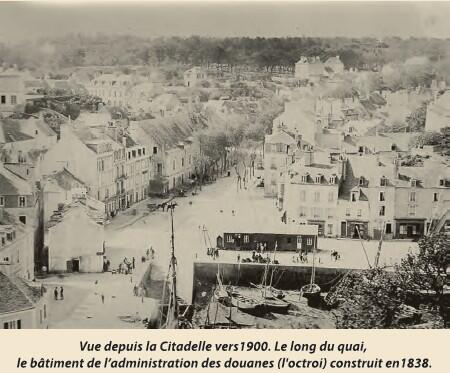
Place de la République
The first inhabitants of Le Palais originally avoided this site, finding it inhospitable—prone to flooding during high tides and nearly impassable in winter due to rainwater runoff and natural springs. Everything changed in 1699, when the "destruction" of the first town of Le Palais on the Basse-Boulogne plateau—ordered to create a clear defensive slope for the Citadel—forced residents to relocate near the port, settling primarily around this square. As the port’s activity grew, so did the number of houses surrounding the area.
A Square of Many Names
Throughout the 17th and 18th centuries, the square bore several names, including Place Marine, Place du Grand Bassin, and Place du Bassin. This reflected its central feature: a large building constructed in 1693 that housed a water reservoir to supply naval vessels. Later, the building was converted into an artillery storehouse. In the mid-18th century, the square was named after the Duke of Aiguillon, Commander-in-Chief of Brittany, who frequently visited Belle-Île to inspect its coastal defenses.
During the French Revolution in 1794, the former naval building was demolished, and a "Liberty Tree" was planted in the center. The site was officially renamed Place de la Liberté and served as the town's main gathering spot for public meetings and festivities. Under the Napoleonic Empire, as it became a preferred parade ground for soldiers on holidays, it was dubbed Place d’Armes.
A Bustling Hub
For a long time, the square was quite cluttered. It was filled with small huts used for salting sardines, public latrines, and a fountain built in 1829. In 1839, it was named Place Charles X to show the island's gratitude for the King's interest in Belle-Île. Between 1882 and 1892, it even served as the station for Le Palais's first lifeboat, the Vauvert-de-Mean. It was finally named Place de la République in 1902, a name it carries to this day.
14
Rue Willaumez
Since 1843, the street connecting the town center to Port-Hallan—the gateway to the road to Locmaria—has borne the name "Willaumez." It was named in honor of Admiral Jean-Baptiste Willaumez, who was born at number 7 on August 7, 1763. His mother was from Sauzon, and his father was a soldier stationed on the island to defend it against the English. Jean-Baptiste Willaumez enjoyed a brilliant naval career; he was appointed Rear-Admiral by Napoleon following a legendary feat in 1804, when his fleet damaged and forced the enemy vessel HMS Hercules to flee.
Willaumez sailed the world’s oceans, and his extraordinary talent earned him recognition across the shifting political regimes of his time. At the age of 57, he was named Vice-Admiral by King Louis XVIII. As a gesture of his enduring affection for Belle-Île, Willaumez gifted his portrait to the towns of Le Palais and Sauzon; these paintings still hang in the town council chambers to this day. In honor of his bravery, his name is also inscribed on the Arc de Triomphe in Paris.
A Street of Bread and Cinema
Rue Willaumez has been known by several names over the centuries, including "Rue des États" and "Rue aux Fours" (Oven Street). The latter name originated because the manor house at number 17 served as the site for the island's communal bread ovens until the French Revolution. In those days, the street was a bustling hub where people from all corners of the island would gather to bake their bread.
More recently, the street was home to Belle-Île’s only cinema, the "Arletty," until the 1990s. The theater was named in reference to the famous French actress Arletty, who was a frequent summer visitor to the island and a great lover of Belle-Île.
15
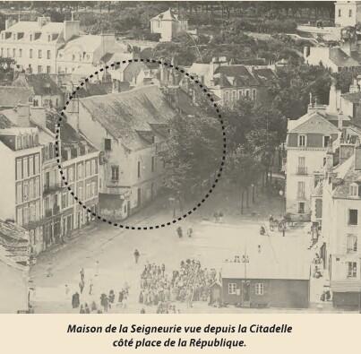
Maison de la Seigneurie et Magasin aux Avoines (The Manor House and the Oat Storehouse)
Over the centuries, the apartments served many purposes: from the residence of Fouquet’s estate manager to the Lordship’s court, and eventually as barracks for French soldiers. During the British occupation (1761–1763), the buildings were used by enemy forces, and later by representatives of the Estates of Brittany tasked with reorganizing the island’s land titles when Belle-Île returned to the French Crown.
During the French Revolution, the "Seigniorial" property became "National" property. The municipality of Le Palais briefly installed its Town Hall here, but the military soon requisitioned the building, installing ovens, a bakery, and horse stables within the vaulted ground floors. It wasn't until the garrison finally departed in 1920 that the building was sold to a private owner.
A Hidden Connection
Facing the Rue de la Manutention, a narrow alleyway separates the Manor House from the Magasin aux Avoines (Oat Storehouse). You can still spot a doorway on the upper level of the Manor House, which was once connected to the storehouse by a bridge. This catwalk allowed grain to be easily transported from the Rue Chasles de la Touche, directly over the street and between the two storage buildings.
A Place of Refuge for the Acadians
Beginning in September 1765, these buildings served as temporary housing for a group of 363 Acadians. These settlers had been deported from their homes in Acadia (Maritime Provinces, Canada) in 1755 and subsequently imprisoned in England. Following the 1763 Treaty of Paris, which secured their freedom and the return of Belle-Île to France, the King invited the Acadians to settle on the island. They were housed here while waiting for land to be allocated and homes to be rebuilt across the island’s four parishes. Today, a commemorative plaque on the wall of the Manor House serves as a lasting tribute to this significant chapter in the island's history.
16
The Sables District
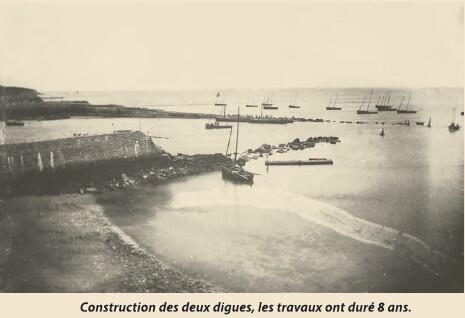
The "Sables" (Sands) district was already mentioned as early as 1659 on the oldest known map of Le Palais. It was situated on a narrow strip of land extending into the sea along the channel. Because the main port would dry out at low tide, this beach—exposed to the easterly winds—was for a long time the only place where boats could land at any hour.
Protecting the channel entrance from the sea’s power became a priority in the 17th century. Nicolas Fouquet ordered the construction of an initial sea wall as an extension of what is now the Quai de l'Yser. It was destroyed during the 1761 siege, only to be rebuilt seven years later. In 1780, a second jetty was constructed on the opposite bank of the channel, at the foot of the Citadel.
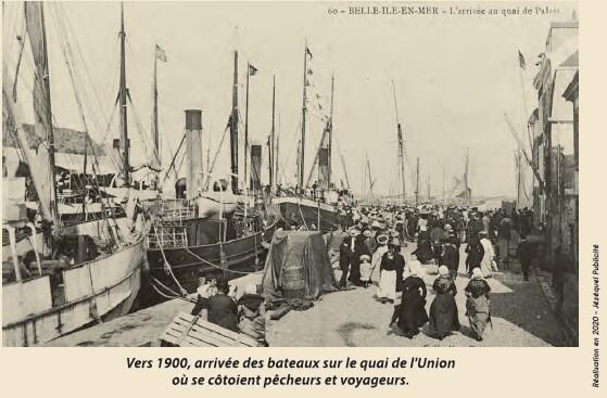
A World of Industry and Character
The Quai de l'Yser was long known as the "Quai de l'Union," named after the maritime company L'Union Belliloise, which operated regular ferry services to the mainland. It was widened in 1890. Opposite the landing port, the Quai Vauban was sheltered from the easterly winds, making it a safe haven. By 1803, it was paved and widened to accommodate the intense daily commercial activity that took place there.
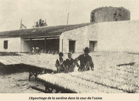
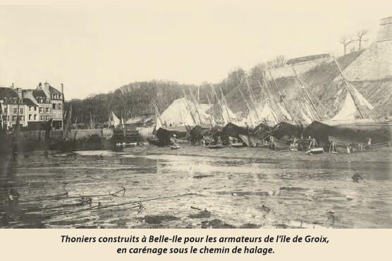
As the quays developed, the Sables district flourished throughout the 19th century. Sailors and fishermen lived in the modest, low-roofed houses lining the four streets of this neighborhood, which was entirely dedicated to fishing and processing sardines—including the prominent Philippe et Canaud factory. It was a place defined by the heavy, pungent air of the industry: fish entrails and waste, rogue (a cod-roe preparation used as sardine bait), salting workshops, and the fish presses where brine would constantly flow.
The narrow alleys were filled with small taverns (estaminets) that served a hardworking, boisterous, and often rowdy population. Although the district has been deeply transformed by the addition of extra stories to most of its buildings, it still retains much of its unique 19th-century character and atmosphere today.
17
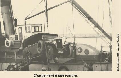
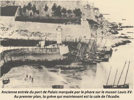
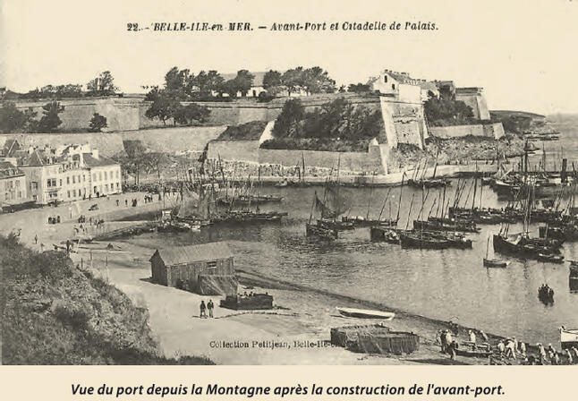
The Outer Harbour
To provide fishing boats with a permanently accessible mooring area and to allow ferries (“courriers”) to dock regardless of the tide while maintaining regular connections with Quiberon, an outer harbour was created at the end of the 19th century.
Built between 1882 and 1890, the outer harbour is protected by two large breakwaters. On the left stands the Bourdelle breakwater, named after the civil engineer in charge of the works; on the right, the Bonnelle breakwater, named after a General Councillor. Two lighthouses mark the harbour entrance at the tips of the breakwaters. An earlier lighthouse, dating from 1838, once stood on the Sables jetty, guiding ships into the channel. After completion of the outer harbour, it was dismantled and reinstalled on the Bourdelle breakwater in 1890 (green light). The right-hand lighthouse (red light) was built in 1892.
Two quays line the waterfront: Acadie Quay and Bonnelle Quay.
Formerly known as Quai des Sables and then Quai Macé in 1800, Acadie Quay was renamed in 1985 in memory of the 78 Acadian families who settled in Belle-Île in 1765. It serves as the “gateway” to Le Palais from the harbour.
From the late 19th century onwards, cafés and several hotels welcomed travellers along the quay.